Browsing this Thread:
5 Anonymous Users
|
Re: Potential Hurricane on Sunday
|
||||
|---|---|---|---|---|
|
Home away from home
 |
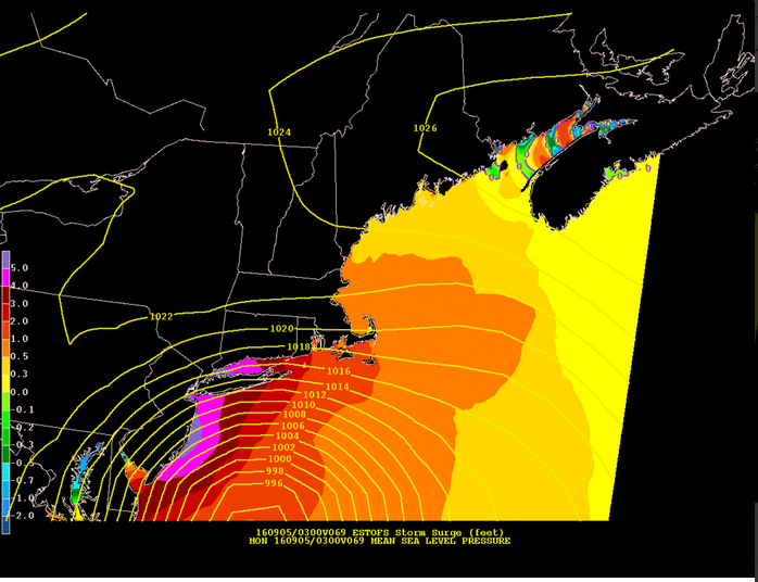
My surge prediction link didn't work.....
Posted on: 2016/9/2 17:10
|
|||
|
||||
|
Re: Potential Hurricane on Sunday
|
||||
|---|---|---|---|---|
|
Home away from home
 
Joined:
2012/9/18 3:58 Last Login : 2021/9/23 15:07 From Between Thought and Expression
Group:
Registered Users
Posts:
907
 |
http://www.huffingtonpost.com/entry/e ... e5045936?utm_hp_ref=world
PSE&G is closely monitoring Tropical Storm Hermine and the possibility it could impact our service territory beginning Sunday. The storm could bring the potential for heavy rain and strong winds as it sweeps up the east coast and possibly lingers into next week. In anticipation of the storm, PSE&G is ensuring that all available personnel are ready to respond beginning early tomorrow morning. We are also ensuring that additional supplies, including poles and transformers, are on hand. Depending on the track of the storm, Hermine may stall off the New Jersey coast, bringing prolonged periods of wind and rain to our service territory. In addition to having additional personnel and equipment at the ready, we are installing barriers at a number of substations to keep water out. We have already elevated several switching and substations above flood level in preparation for this kind of severe weather. PSE&G urges you to be cautious if you see downed lines. Downed wires should always be considered "live." Do not approach or drive over a downed line and do not touch anything that it might be in contact with. To report downed wires or power outages, call PSE&G's Customer Service line at 1-800-436-PSEG. You can also report power outages and view the status of an outage by logging in to My Account on pseg.com, PSE&G's mobile-friendly website. PSE&G offers the following tips to help you prepare: ? Charge your cell phones, tablets and other mobile devices. ? Fill up your car's fuel tank. ? Check your supply of flashlights, blankets, nonperishable food and bottled water for everyone in your family. ? Put your refrigerator and freezer at the coldest setting. Keep a blanket handy to throw over these appliances for added insulation. If electricity is interrupted, keep refrigerator and freezer doors closed as much as possible. ? Compile a list of emergency phone numbers, including PSE&G's Customer Service line: 1-800-436-PSEG. Call this number to report power outages or downed wires. Stay Connected with PSE&G'S MyAlerts and Outage Center Sign up for PSE&G's MyAlerts service for 2-way texting and email notifications. PSE&G's free MyAlerts service allows you to: ? Text OUT to report a power outage. ? Text STAT at any time for the latest on your outage. ? Receive an alert when there is a power outage in your area. ? Receive notification of your Estimated Time of Restoration (ETR) and changes in the ETR of more than an hour. ? Receive an alert when the power outage is restored. There are two ways to register for MyAlerts: ? Log in to My Account at pseg.com from your smart phone, tablet, or computer and select "MyAlerts Text/Email Notifications" from the main menu. You can select which alerts you'd like to receive and how you would like to receive them. ? Use your mobile phone to text "REG" to 47734 (4PSEG), and then follow the prompts to register for text alerts. Stay in touch and informed with PSE&G's "Outage Center" to: ? Report an outage and check your outage status. ? View our "Outage Map," updated every 15 minutes, which displays the location and status of power outages in our service territory. ? Receive important safety information to help you before, during and after a storm. ? Sign up as a follower of PSE&G's Twitter and Facebook pages to monitor restoration progress.
Posted on: 2016/9/2 16:52
|
|||
|
||||
|
Re: Potential Hurricane on Sunday
|
||||
|---|---|---|---|---|
|
Home away from home
 |
Posted on: 2016/9/2 16:11
|
|||
|
||||
|
Re: Potential Hurricane on Sunday
|
||||
|---|---|---|---|---|
|
Home away from home
 
|
Looks like we might not get too much. Thanks for all this info -- MDM & also thanks to Brewster for surge link.
Posted on: 2016/9/2 15:46
|
|||
|
||||
|
Re: Potential Hurricane on Sunday
|
||||
|---|---|---|---|---|
|
Home away from home
 
|
Quote:
So for those of you who are good at parsing these numbers, what's your best sense of flooding potential downtown? It doesn't sound anything close to the scope of Sandy, but how bad is it likely to get for flood-prone streets or those who live in garden-level apartments?
Posted on: 2016/9/2 15:19
|
|||
|
||||
|
Re: Potential Hurricane on Sunday
|
||||
|---|---|---|---|---|
|
Home away from home
 
|
Quote:
Just to be clear for the newbies, there's 2 metrics used, peak high water, and "surge over predicted tide". The number I posted was the latter. During Sandy the news confused the hell out of people mixing them up. The SURGE over the normal predicted tide was 9', HIGH WATER was 14. To be even more confusing, there's 2 baselines that might be used, Mean Low Water, the most common, vs Average Height.
Posted on: 2016/9/2 15:06
|
|||
|
||||
|
Re: Potential Hurricane on Sunday
|
||||
|---|---|---|---|---|
|
Home away from home
 |
Posted on: 2016/9/2 14:31
|
|||
|
||||
|
Re: Potential Hurricane on Sunday
|
||||
|---|---|---|---|---|
|
Home away from home
 |
Quote:
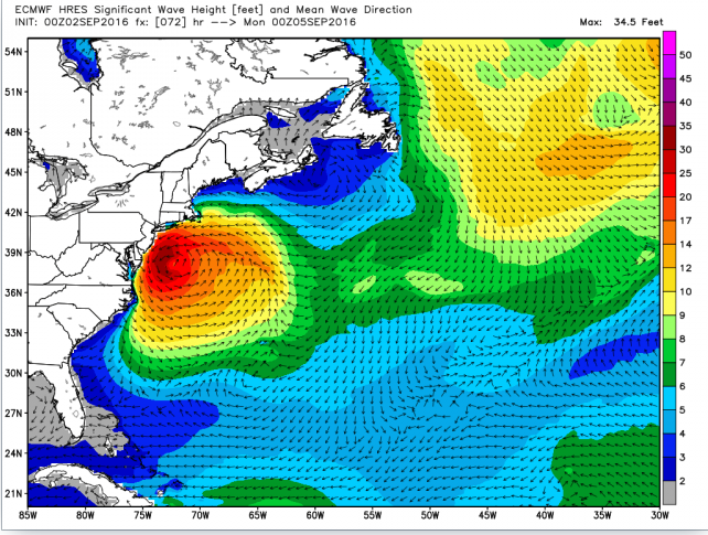
If you are on a barrier island, you might want to make plans on bugging out. 15ft+ waves and a possible big storm surge. Bigger the farther south you go.
Posted on: 2016/9/2 14:29
|
|||
|
||||
|
Re: Potential Hurricane on Sunday
|
||||
|---|---|---|---|---|
|
Home away from home
 |
How's the Jersey shore looking?
Posted on: 2016/9/2 13:54
|
|||
|
||||
|
Re: Potential Hurricane on Sunday
|
||||
|---|---|---|---|---|
|
Home away from home
 
|
Quote:
Thanks for the continued updates, MDM. They're very helpful.
Posted on: 2016/9/2 13:40
|
|||
|
||||
|
Re: Potential Hurricane on Sunday
|
||||
|---|---|---|---|---|
|
Home away from home
 |
Edit:
Rain totals are modeled to b 0.25 inch or less.
Posted on: 2016/9/2 13:04
|
|||
|
||||
|
Re: Potential Hurricane on Sunday
|
||||
|---|---|---|---|---|
|
Home away from home
 |
Quote:
The monitoring equipment failed when the surge hit 12 ft at Battery Park. I read it was up to 14 ft in places.
Posted on: 2016/9/2 13:02
|
|||
|
||||
|
Re: Potential Hurricane on Sunday
|
||||
|---|---|---|---|---|
|
Home away from home
 
|
Quote:
For comparison, how high were the surges during Sandy?
Posted on: 2016/9/2 12:58
|
|||
|
||||
|
Re: Potential Hurricane on Sunday
|
||||
|---|---|---|---|---|
|
Home away from home
 |
The three models I looked at show the storm hanging off our coast, with the really heavy rain down in South Jersey. Up by us its going to be an inch of rain and a lot of wind.
All three are still showing this storm stalling off the coast of South Jersey and then slowly moving away. It appears we are going to have this storm around for 72+ hours starting on Sunday. Weatherbell predicts the same, though they have the track closer to the coast than the models. They are also predicting it intensifying to a category 2 storm once it exits North Carolina, due to the unusually warm water off the coast.
Posted on: 2016/9/2 12:29
|
|||
|
||||
|
Re: Potential Hurricane on Sunday
|
||||
|---|---|---|---|---|
|
Home away from home
 
|
Stevens has the surge at only ~1.7 feet right now. Hope it stays there.
http://hudson.dl.stevens-tech.edu/sfas/d/index.shtml?station=N017
Posted on: 2016/9/2 1:07
|
|||
|
||||
|
Re: Potential Hurricane on Sunday
|
||||
|---|---|---|---|---|
|
Home away from home
 Joined:
2007/4/16 13:46 Last Login : 2023/11/15 11:50 From Village/HP
Group:
Registered Users
Posts:
536
 |
Thanks, MDM.
I'm not sure why half the counties in NJ, including western and northern ones like Sussex and Hunterdon have hurricane weather statement alerts or watches but Hudson doesn't?
Posted on: 2016/9/2 0:58
|
|||
|
||||
|
Re: Potential Hurricane on Sunday
|
||||
|---|---|---|---|---|
|
Home away from home
 |
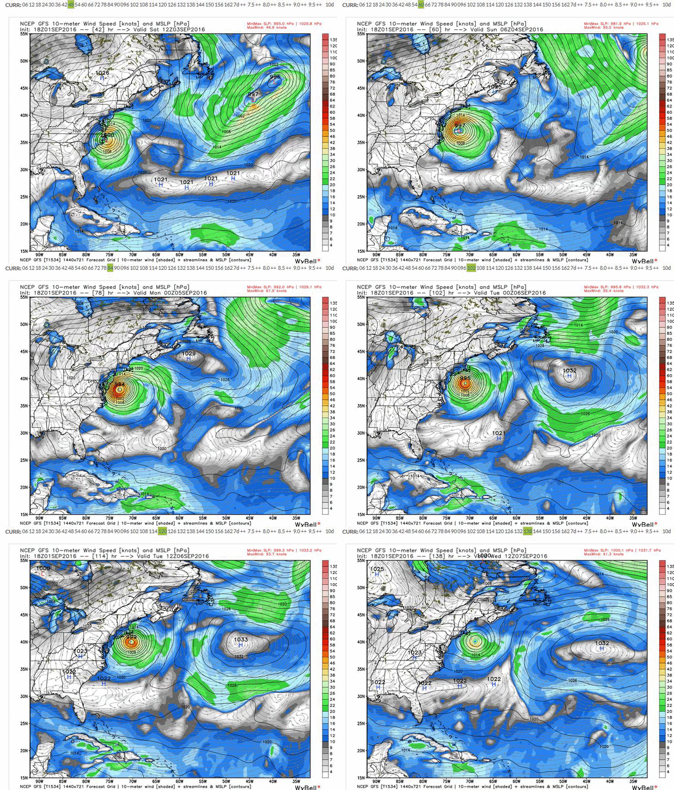
The evening update for the GFS model has the storm stalling farther east and then going out to sea. This is fairly positive for us as we don't get that much rain (less than an inch), the wind isn't too awful. The biggest threat comes from storm surge during high tide for the people in the downtown.
Posted on: 2016/9/1 23:20
|
|||
|
||||
|
Re: Potential Hurricane on Sunday
|
||||
|---|---|---|---|---|
|
Home away from home
 |
Quote:
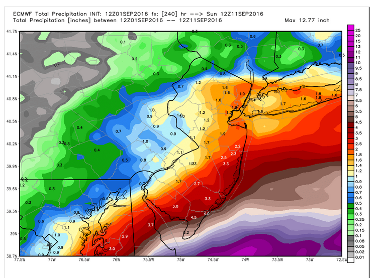
I am just showing what the Euro model shows which updated only 2 hours ago. The NOAA model hasn't been updated as recently. The Euro shows almost no additional rain after the storm pulls out mid week, within the 10 day period. The Euro has been better than the other models in forecasting Atlantic storms.
Posted on: 2016/9/1 19:34
|
|||
|
||||
|
Re: Potential Hurricane on Sunday
|
||||
|---|---|---|---|---|
|
Home away from home
 Joined:
2014/9/16 19:15 Last Login : 2019/2/27 14:41 From Jersey City
Group:
Registered Users
Posts:
500
 |
The ten day rain forecast? How responsible of you
 The five day gives us 1-1.25" of rain 
Posted on: 2016/9/1 19:22
|
|||
|
||||
|
Re: Potential Hurricane on Sunday
|
||||
|---|---|---|---|---|
|
Home away from home
 |
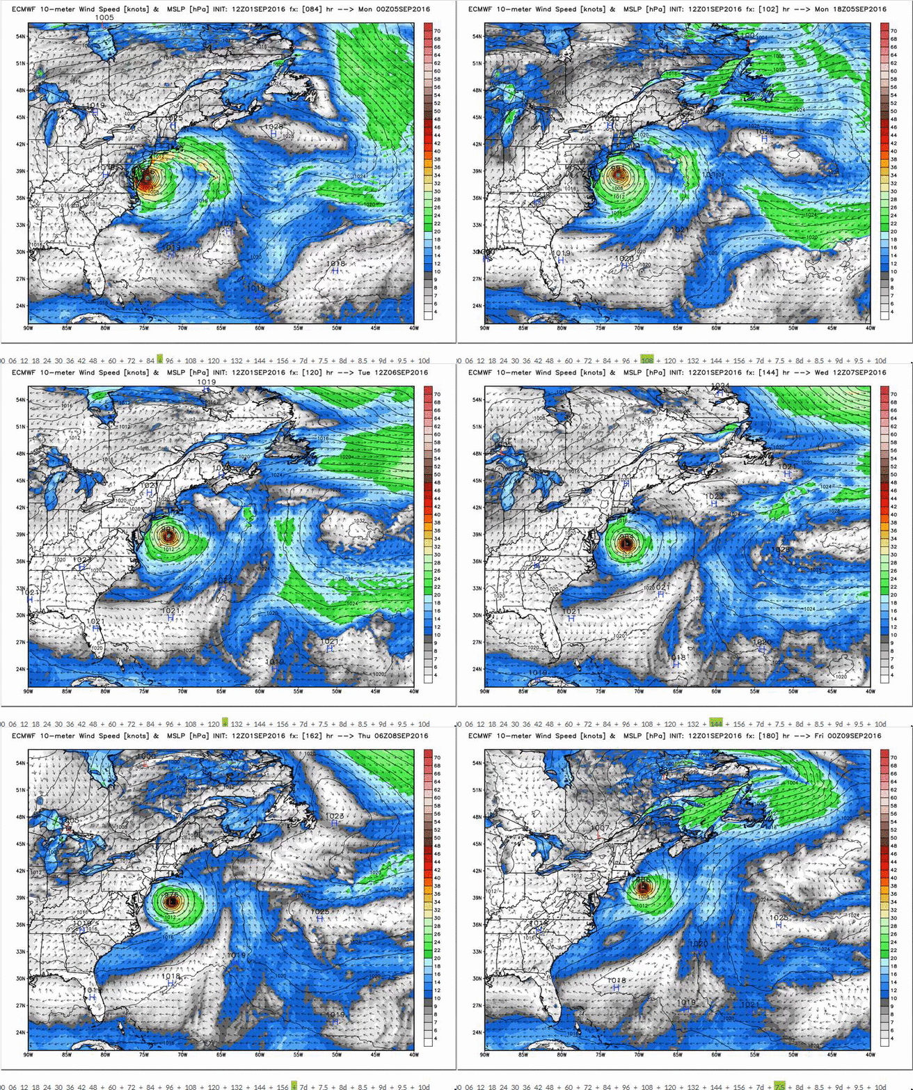
Updated Euro. It shows the stall like the Canadian, but farther out to sea. South Jersey gets the worse of it with near hurricane force winds along the shore.
Posted on: 2016/9/1 19:12
|
|||
|
||||
|
Re: Potential Hurricane on Sunday
|
||||
|---|---|---|---|---|
|
Home away from home
 
Joined:
2009/3/19 15:20 Last Login : 2020/6/2 11:06 From Scenic McGinley Square
Group:
Registered Users
Posts:
709
 |
Quote:
Imprylfsh wrote:
Posted on: 2016/9/1 19:09
|
|||
|
||||
|
Re: Potential Hurricane on Sunday
|
||||
|---|---|---|---|---|
|
Newbie
 |
For those of you who weren't here or don't remember Irene, here's a video from the archives: https://www.youtube.com/watch?v=QclerlKTZ3k
Posted on: 2016/9/1 17:56
|
|||
|
||||
|
Re: Potential Hurricane on Sunday
|
||||
|---|---|---|---|---|
|
Home away from home
 |
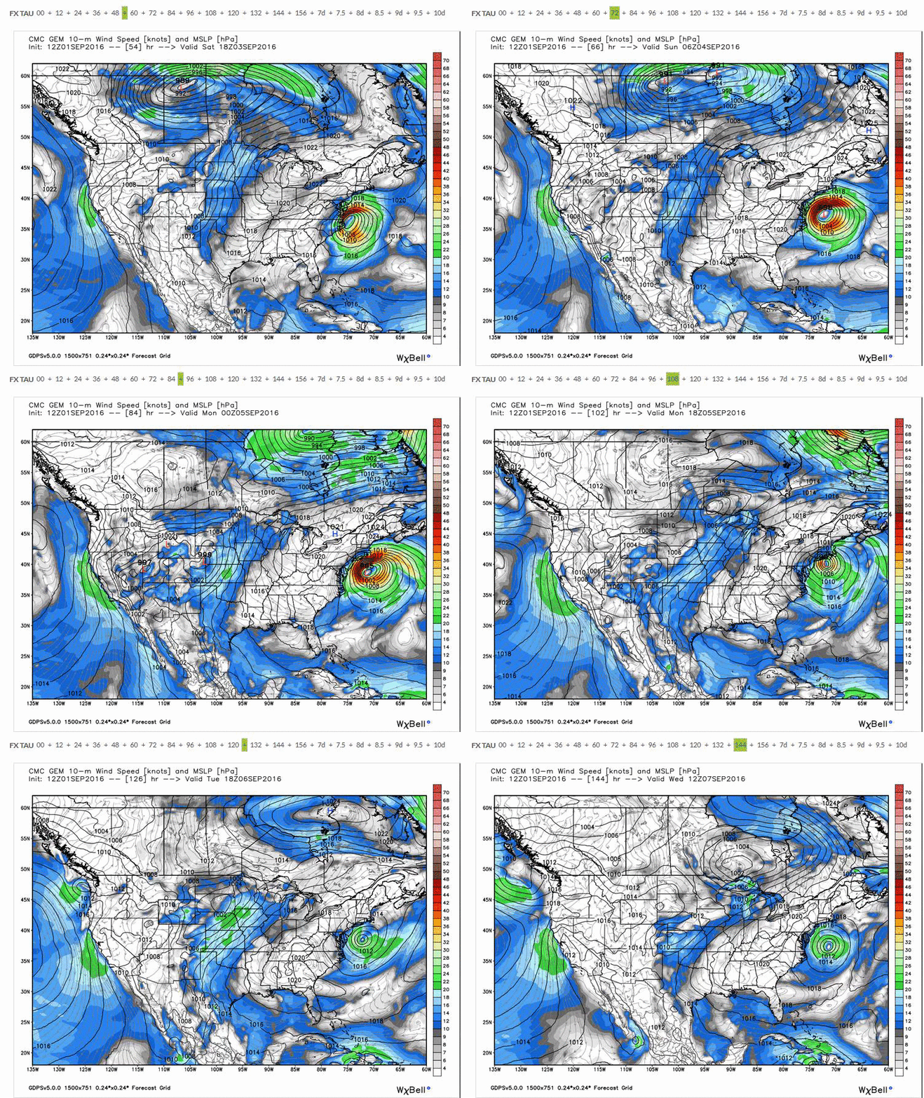
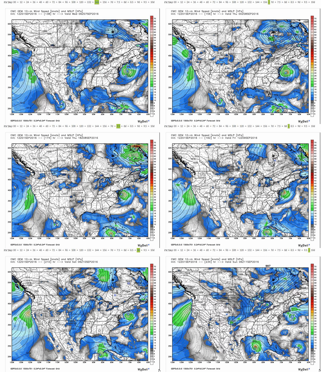
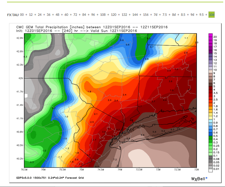
The updated Canadian model is now showing a tropical storm stalling over us for days. Had to break up the run in two gifs below. I also posted the 10 day rain totals, which show flood level inducing rains (sorry Brewster)....
Posted on: 2016/9/1 17:14
|
|||
|
||||
|
Re: Potential Hurricane on Sunday
|
||||
|---|---|---|---|---|
|
Just can't stay away
 
|
Posted on: 2016/9/1 16:43
|
|||
|
||||
|
Re: Potential Hurricane on Sunday
|
||||
|---|---|---|---|---|
|
Home away from home
 |
MDW, I appreciate you alerting us to this issue well before the media. Hopefully nothing will happens, but it gave me a few extra days of notice. I had travel planned for this week and was able to make some adjustments. Last thing I wanted is to be stranded in an airport.
Posted on: 2016/9/1 14:03
|
|||
|
||||
|
Re: Potential Hurricane on Sunday
|
||||
|---|---|---|---|---|
|
Home away from home
 |
Weatherbell's morning update:
Pretty much the same as yesterday: Cat 1/2 storm sits off the coast, eventually skating past Eastern Long Island and RI.
Posted on: 2016/9/1 12:34
|
|||
|
||||
|
Re: Potential Hurricane on Sunday
|
||||
|---|---|---|---|---|
|
Home away from home
 |
For inland flooding, the 2007 nor'easter produced worse flooding downtown than both Irene and Sandy.
http://www.nytimes.com/2007/04/16/nyregion/16storm.html http://www.hudsonreporter.com/view/fu ... ate-from-stormwater-pipes
Posted on: 2016/9/1 12:13
|
|||
|
||||
|
Re: Potential Hurricane on Sunday
|
||||
|---|---|---|---|---|
|
Home away from home
 |
Quote:
Irene hit us after two months of exceptionally wet weather. I lost a pear-apple tree because the ground beneath it basically liquefied. The roots had nothing to hold onto.
Posted on: 2016/9/1 11:54
|
|||
|
||||
|
Re: Potential Hurricane on Sunday
|
||||
|---|---|---|---|---|
|
Home away from home
 |
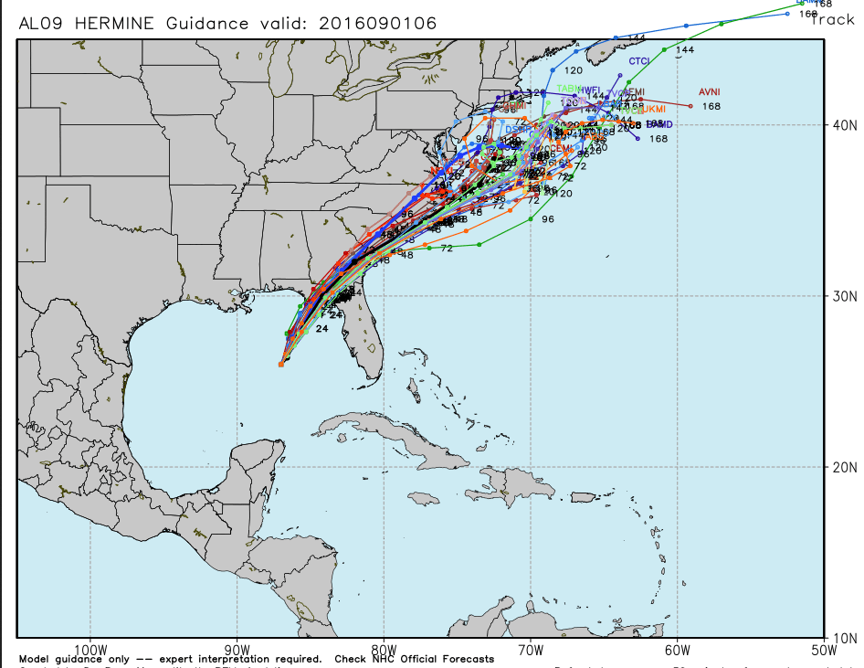
The models show the storm stalling off the Mid Atlantic. Where it goes after the stall period is the issue. The models however, show the storm shifting further West now, which is not good for us.
Posted on: 2016/9/1 11:51
|
|||
|
||||


