Browsing this Thread:
1 Anonymous Users
|
Re: Potential Hurricane on Sunday
|
||||
|---|---|---|---|---|
|
Home away from home
 |
Quote:
Sandy had a 9 ft surge over high tide. Inland the impact was closer to 5-6 ft on this map. Probably worse on the waterfronts. The amount of rainfall, and the "bathtub" effect is a huge variable. http://ss2.climatecentral.org/#14/40. ... vel=6&unit=feet&pois=hide
Posted on: 2016/9/6 18:53
|
|||
|
||||
|
Re: Potential Hurricane on Sunday
|
||||
|---|---|---|---|---|
|
Home away from home
 |
Quote:
And why does your uneducated guess mean anything anyways?
Posted on: 2016/9/6 17:29
|
|||
|
||||
|
Re: Potential Hurricane on Sunday
|
||||
|---|---|---|---|---|
|
Home away from home
 Joined:
2007/4/16 13:46 Last Login : 2023/11/15 11:50 From Village/HP
Group:
Registered Users
Posts:
536
 |
Quote:
Do you flood?
Posted on: 2016/9/6 17:07
|
|||
|
||||
|
Re: Potential Hurricane on Sunday
|
||||
|---|---|---|---|---|
|
Home away from home
 
Joined:
2005/11/12 17:04 Last Login : 5/7 14:26 From Downtown JC, VVP Area
Group:
Registered Users
Posts:
560
 |
Quote:
Yeah, well, a minor hurricane or tropical storm-force wind missing you by less than 50 miles is just plain luck. MDM was just reading the models at least twice a day and sharing the latest and most accurate predictions with us. I appreciated his insights. You made an uneducated guess it would miss us and you were right THIS TIME. Gloating over a lucky guess doesn't get you any brownie points... That aside, I feel bad for all the Jersey Shore businesses who decided to board up and sandbag (based on the forecasts) and probably lost the most lucrative weekend of the summer season.
Posted on: 2016/9/6 17:04
|
|||
|
||||
|
Re: Potential Hurricane on Sunday
|
||||
|---|---|---|---|---|
|
Home away from home
 |
Quote:
oh i just mean downtown jc
Posted on: 2016/9/6 16:06
|
|||
|
||||
|
Re: Potential Hurricane on Sunday
|
||||
|---|---|---|---|---|
|
Home away from home
 
Joined:
2005/11/12 17:04 Last Login : 5/7 14:26 From Downtown JC, VVP Area
Group:
Registered Users
Posts:
560
 |
Quote:
Tell that to the people who live on some stretches of the the south shore of Long Island. Bay Shore has about 3' of water in the commercial district of town.
Posted on: 2016/9/6 15:28
|
|||
|
||||
|
Re: Potential Hurricane on Sunday
|
||||
|---|---|---|---|---|
|
Home away from home
 |
Quote:
You didn't know what you were talking about then and you still don't now.
Posted on: 2016/9/6 14:42
|
|||
|
||||
|
Re: Potential Hurricane on Sunday
|
||||
|---|---|---|---|---|
|
Home away from home
 |
Quote:
see nothing to worry about.
Posted on: 2016/9/6 14:37
|
|||
|
||||
|
Re: Potential Hurricane on Sunday
|
||||
|---|---|---|---|---|
|
Home away from home
 |
Looks like the entire Jersey Shore is dodging the bullet this time.
The hurricane is tracking farther west with no big loop back. Wind and rough surf for us only it seems.
Posted on: 2016/9/4 10:29
|
|||
|
||||
|
Re: Potential Hurricane on Sunday
|
||||
|---|---|---|---|---|
|
Home away from home
 |
Quote:
... in Ocean, Atlantic and Cape May counties only
Posted on: 2016/9/4 2:46
|
|||
|
||||
|
Re: Potential Hurricane on Sunday
|
||||
|---|---|---|---|---|
|
Home away from home
 
Joined:
2012/1/11 18:21 Last Login : 2019/12/26 15:30 From GV Bayside Park
Group:
Registered Users
Posts:
5356
 |
A state of emergency has been declared. Major flooding is expected. If you have a car you might want to park it up the hill. B safe.
Posted on: 2016/9/4 1:51
|
|||
|
||||
|
Re: Potential Hurricane on Sunday
|
||||
|---|---|---|---|---|
|
Home away from home
 |
Another note from Weatherbell:
The models are agreeing there is going to be a loop back to the West. They are not in agreement as to where. Right now, it looks like worse than Sandy in South Jersey with the added insult of having this surge repeat for possibly three days.
Posted on: 2016/9/3 18:58
|
|||
|
||||
|
Re: Potential Hurricane on Sunday
|
||||
|---|---|---|---|---|
|
Home away from home
 |
This model is showing the worst case loop back for South Jersey:
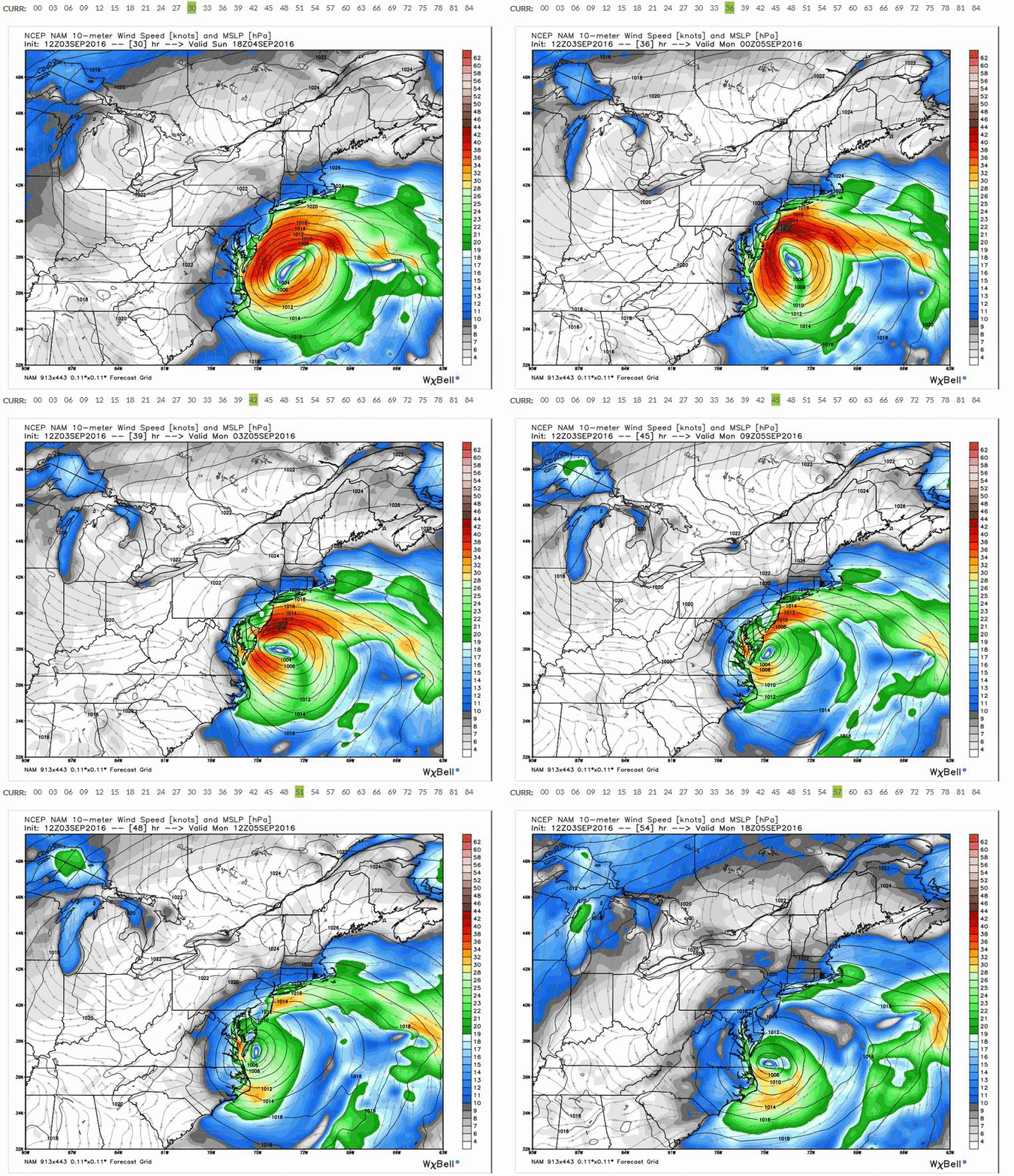 Here is the surge prediction for around Barnegat Light: 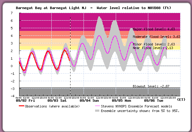 However, if you look at the northern part of Barnegat Bay, you get the opposite of surge: 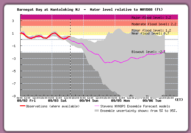
Posted on: 2016/9/3 18:12
|
|||
|
||||
|
Re: Potential Hurricane on Sunday
|
||||
|---|---|---|---|---|
|
Home away from home
 |
Quote:
The surge estimates are all over the map, depending on where you get you info now. The fact that they are getting VERY high tides already in South Jersey though is an ominous sign. The same was true for Sandy. Per Weatherbell, the fear is the storm looping to the West. Joe Bastardi thinks the models may have the storm moving too far East. If you get a move to the West, the NE winds and the very low barometric pressure will move a whole lot of water to the shore. To quote Bastardi, "worse than Sandy" for areas around Atlantic City south to Ocean City, MD.
Posted on: 2016/9/3 17:57
|
|||
|
||||
|
Re: Potential Hurricane on Sunday
|
||||
|---|---|---|---|---|
|
Home away from home
 
|
Quote:
You need to talk to a local. I think these things vary tremendously. Currently Stevens shows a surge peak at 3am Monday, with high tide at 12am. The graphs indicate a peak of 2.5' over high tide. With no rain that should be no problem for DTJC. Don't know about other parts of town that typically flood from nor'easter surges.
Posted on: 2016/9/3 16:23
|
|||
|
||||
|
Re: Potential Hurricane on Sunday
|
||||
|---|---|---|---|---|
|
Home away from home
 
|
Quote:
Just saw this comment from the NJ.com site - interesting observation: jjerseycity22 (11:38am posting) I really dont get the lack of coverage or respect given to this storm. Was just down in belford. 2 hrs after high tide. Water line was 1 foot below top of bulkhead. And thats 24 hrs before storm really intensifies. Not saying to panic, but this is not something to be toyed with. Its almost as if people are in denial because of the holiday. Source
Posted on: 2016/9/3 15:52
|
|||
|
||||
|
Re: Potential Hurricane on Sunday
|
||||
|---|---|---|---|---|
|
Home away from home
 
Joined:
2008/1/3 19:12 Last Login : 2020/9/30 18:46 From Van Vorst Park
Group:
Registered Users
Posts:
2391
 |
MDM and Brewster and other weather experts - I currently have my boat at the north end of the Barnegat Bay at the mouth of the Pt. Pleasant Canal.
If they are calling for 3-5 ft surge, is that number mirrored in the back bays? Was originally planning on taking it on the ocean back to NY Harbor tomorrow, but obviously that plan is entirely altered.
Posted on: 2016/9/3 15:39
|
|||
|
||||
|
Re: Potential Hurricane on Sunday
|
||||
|---|---|---|---|---|
|
Home away from home
 
|
Quote:
So with this model it seems like we will not get too much rain and wind -- how does flooding / surge look? Are all the models showing the storn tracking further out to sea? NJ.com says the South Jersey shore areas will still get 3-5 feet surge flooding. http://www.nj.com/weather/index.ssf/2 ... om_jersey_shore_beca.html
Posted on: 2016/9/3 10:48
|
|||
|
||||
|
Re: Potential Hurricane on Sunday
|
||||
|---|---|---|---|---|
|
Home away from home
 |
New Euro model run:
Storm tracks farther out to sea, but has greater intensity. The loop back isn't as pronounced, but the storm still sticks around forever. Track map, peak winds, rain totals: 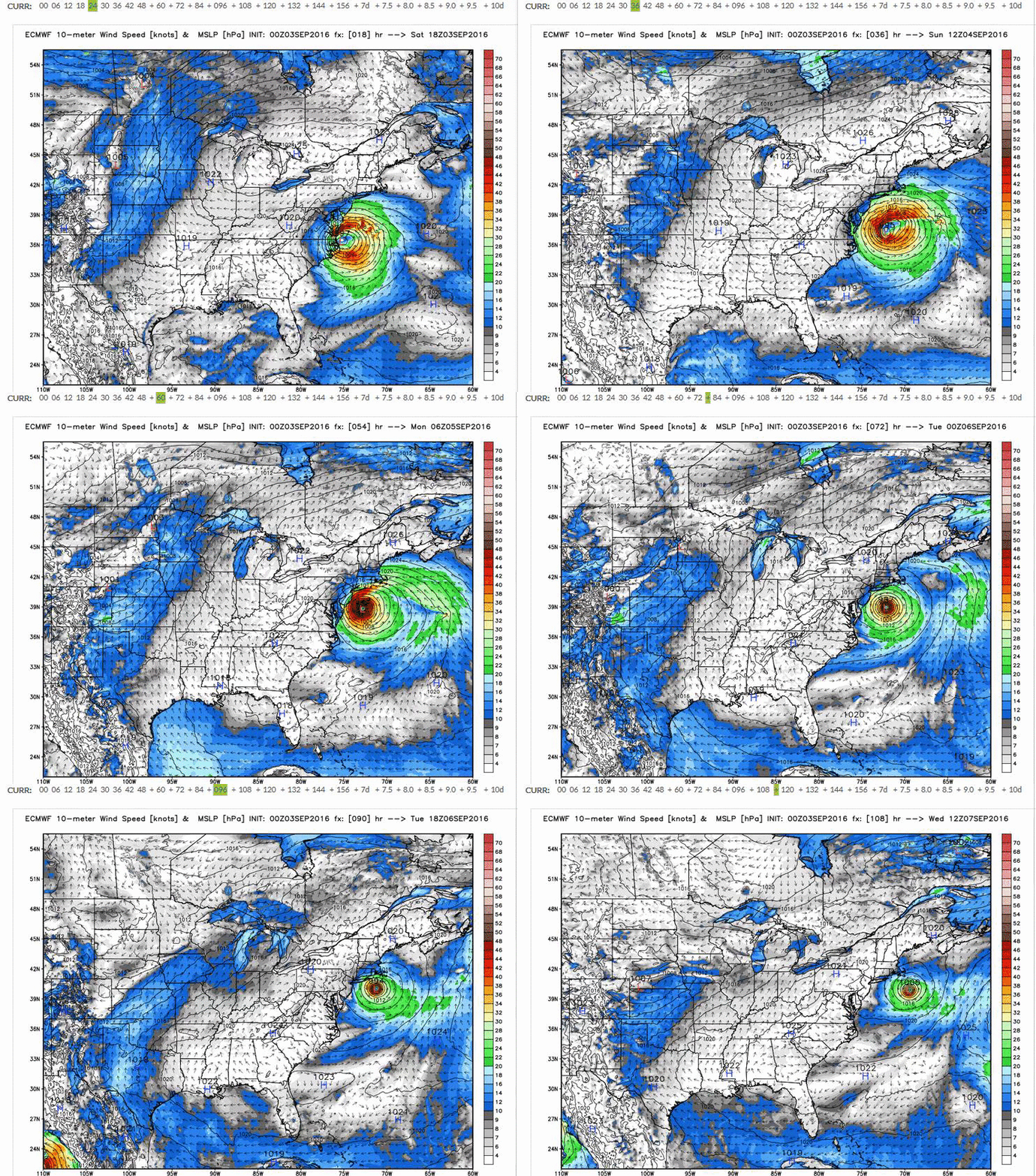 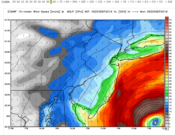 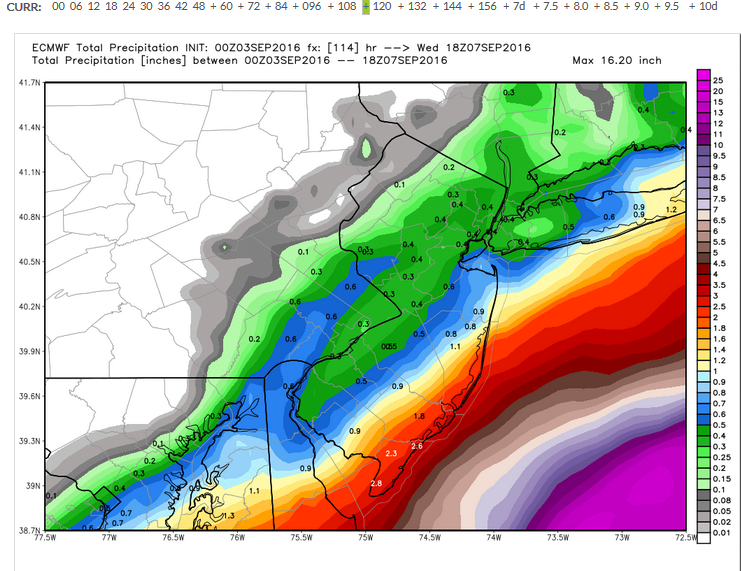
Posted on: 2016/9/3 7:32
|
|||
|
||||
|
Re: Potential Hurricane on Sunday
|
||||
|---|---|---|---|---|
|
Home away from home
 
|
Maybe Sun, Mon, Tues, Wed, Thurs ... who can tell?
Quote:
Posted on: 2016/9/3 1:20
|
|||
|
||||
|
Re: Potential Hurricane on Sunday
|
||||
|---|---|---|---|---|
|
Home away from home
 |
So which day is going to be worse: saturday or sunday?
Posted on: 2016/9/3 1:18
|
|||
|
||||
|
Re: Potential Hurricane on Sunday
|
||||
|---|---|---|---|---|
|
Home away from home
 
|
Sounds very bad for South Jersey Shore areas -- sure hope we aren't also going to get it.
The impacts from a stalled and strengthening storm just off the Jersey Coast could be devastating, and may rival Superstorm Sandy in some areas. http://blogs.mprnews.org/updraft/2016 ... -big-impact-jersey-shore/ =============== SEAN SUBLETTE: What we?re really concerned about going forward into tomorrow, as the center of storm goes up the southeastern coast, affects Hampton Roads, Virginia, and then, as we alluded to earlier on in the broadcast, going off New Jersey or Delmarva Peninsula, and likely just stalling for two or three days, and may attain hurricane status once again. But, really, the biggest story is going to be the tremendous coastal flooding. If this system just hangs off the New Jersey or Delmarva Peninsula and spins for two or three days, you will have a broad area of winds coming onshore. That will likely lead to some serious coastal flooding. WILLIAM BRANGHAM: So, why is the stalling important? I take it you?re saying, we would prefer it to just rush through more quickly? SEAN SUBLETTE: Absolutely. Most of the time, once these systems push northward, they begin to accelerate back out to sea. The steering winds, however, with this particular system look like they are going to set up so that it?s going to stall once it clears off the Virginia Capes and just offshore, only 100 miles or. So, if it just sits and spins in that counterclockwise direction, you have a continuous fetch of water onto shore from those strong northeasterly winds. And that?s what?s going to pile up the water along the coast. http://netnebraska.org/node/1040365
Posted on: 2016/9/3 0:55
|
|||
|
||||
|
Re: Potential Hurricane on Sunday
|
||||
|---|---|---|---|---|
|
Home away from home
 |
Latest GFS model shows the storm basically parking itself off South Jersey until sometime on Thursday.
Weatherbell is predicted an 8 to 12 foot storm surge for areas from Atlantic City south to Ocean City, MD. Edit: The extreme surge is predicted if the storm loops back to land. 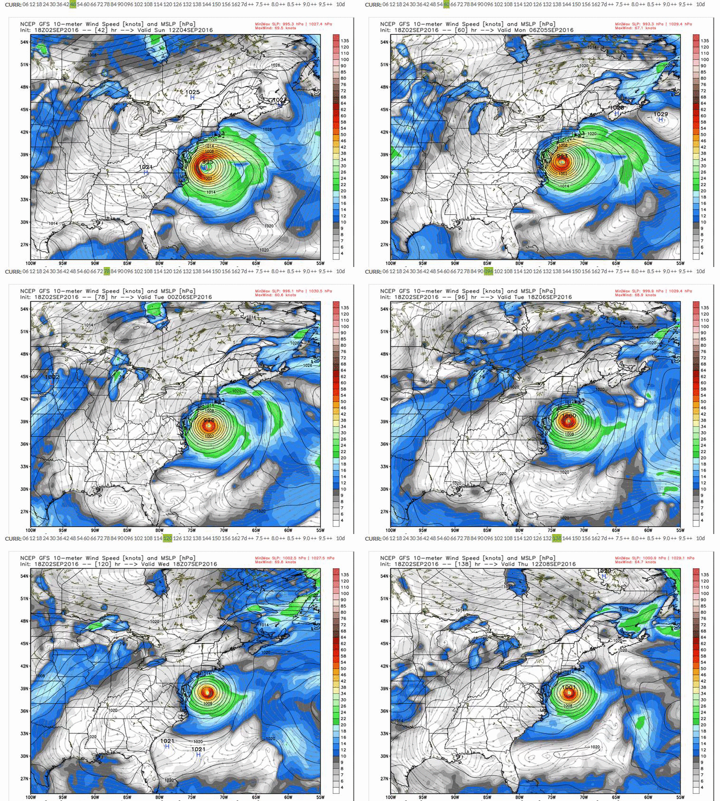
Posted on: 2016/9/3 0:13
|
|||
|
||||
|
Re: Potential Hurricane on Sunday
|
||||
|---|---|---|---|---|
|
Home away from home
 
|
The low rain prediction is great, but it looks like it only needs to shift 30 miles NW to hammer us with >3". Wind doesn't worry me as much, the Downtown grid has proven ridiculously robust over the years, even in the big blackout. But I topped off and tested the generator just in case.
Posted on: 2016/9/2 21:37
|
|||
|
||||
|
Re: Potential Hurricane on Sunday
|
||||
|---|---|---|---|---|
|
Home away from home
 |
Quote:
Its an different computer model. I don't have access to it, but weather guys have been passing the results of it around on twitter.
Posted on: 2016/9/2 19:58
|
|||
|
||||
|
Re: Potential Hurricane on Sunday
|
||||
|---|---|---|---|---|
|
Home away from home
 
|
Great stuff -- THANKS!
New York Magazine just put out an article on the storm (click below) http://nymag.com/daily/intelligencer/ ... -going-to-affect-nyc.html ...and here is a good twitter feed for NYC Hurricane info: https://twitter.com/search?q=Hermine+n ... mp%5Enews%7Ctwgr%5Esearch
Posted on: 2016/9/2 19:47
|
|||
|
||||
|
Re: Potential Hurricane on Sunday
|
||||
|---|---|---|---|---|
|
Home away from home
 |
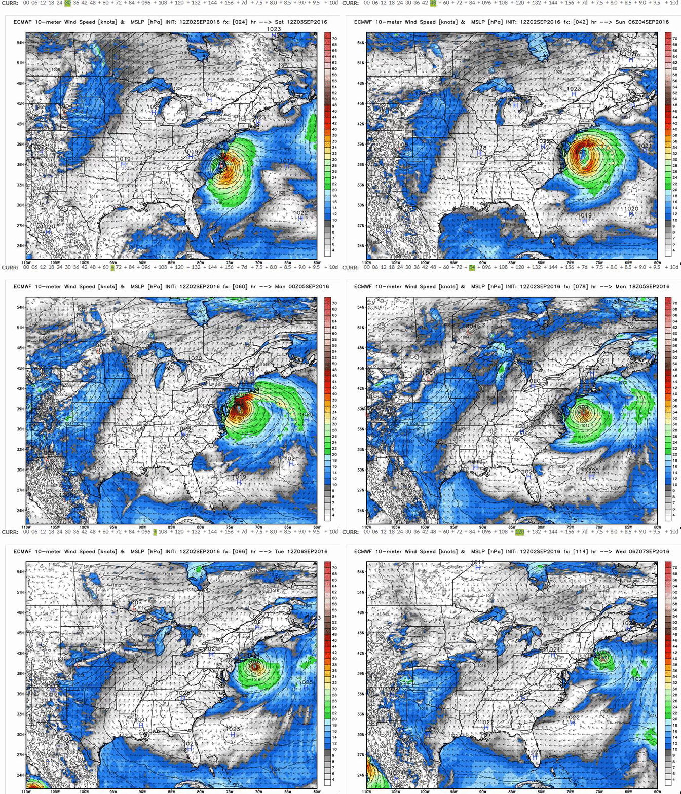
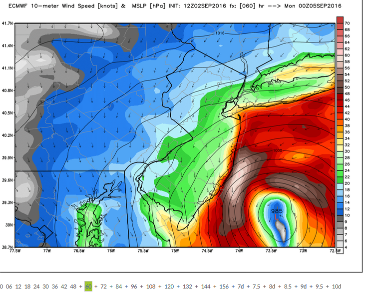
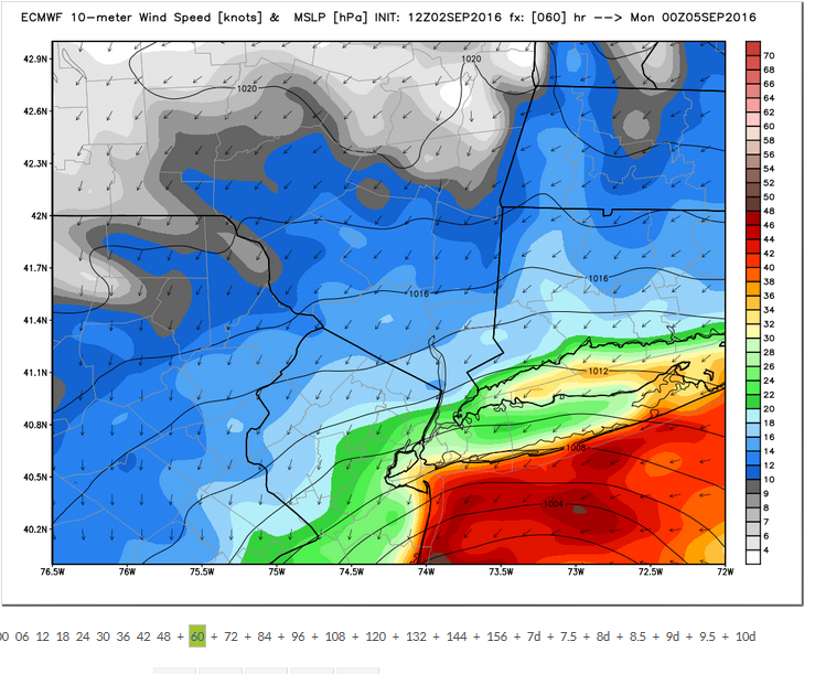
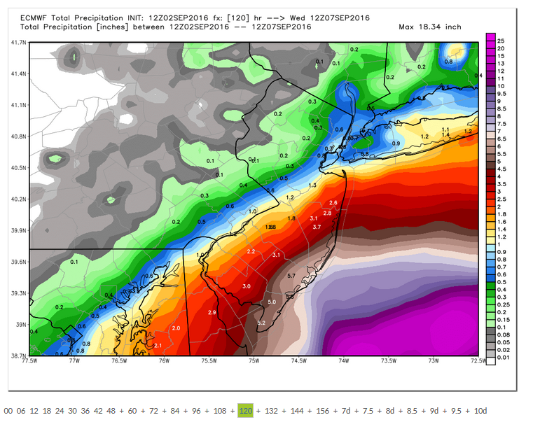
Latest run of the Euro model. It is tracking pretty close from the Weatherbell's last update, but with lower wind speeds. I posted the peak winds for the Jersey Shore and North Jersey / Long Island. Rain is pretty much kept down in South Jersey.
Posted on: 2016/9/2 19:43
|
|||
|
||||
|
Re: Potential Hurricane on Sunday
|
||||
|---|---|---|---|---|
|
Home away from home
 
|
The rise in sea level and storm tide combined puts the odds of storm waters overtopping Manhattan?s defenses at one in every 4 to 5 years, compared to only once in every 100 to 400 years in the 19th century, the study found. (Put another way, the annual chance of a storm overtopping the seawall has gone from about 1 percent to 20-25 percent.)
The storm tide at Battery Park, at the tip of Manhattan, during Hurricane Sandy reached a record 14.06 feet according to the National Hurricane Center?s report on Sandy. That high storm tide ? more than 4 feet higher than the previous record set in December 1992 and the largest since 1821 ? was created by a 9.4-foot storm surge and the evening high tide during a full moon, when tides are higher than normal (though the evening high tide was not as large as the morning one). The extreme rise in water level sent the Harbor flooding into the streets of the Financial District and other parts of Manhattan, as well as other city boroughs at depths between 2 to 9 feet above ground level. An estimated 305,000 houses in New York were destroyed, mostly by storm surge, according to the NHC. Total damage to the city was estimated at $19 billion, including $5 billion in damage to the city?s subway systems caused by flooding. At least 21 people were killed by the storm surge on Staten Island. http://www.climatecentral.org/news/st ... -1-in-every-4-years-17344 also: ...11 billion gallons of untreated and partially treated sewage flowed into rivers, bays, canals, and in some cases, city streets, largely as a result of record storm-surge flooding that swamped the region?s major sewage treatment facilities. To put that in perspective, 11 billion gallons is equal to New York?s Central Park stacked 41 feet high with sewage, or more than 50 times the BP Deepwater Horizon oil spill. The vast majority of that sewage flowed into the waters of New York City and northern New Jersey in the days and weeks during and after the storm. http://www.climatecentral.org/news/11 ... rom-hurricane-sandy-15924
Posted on: 2016/9/2 18:57
|
|||
|
||||
|
Re: Potential Hurricane on Sunday
|
||||
|---|---|---|---|---|
|
Home away from home
 
|
Any idea why they're showing twice the surge that Stevens is?
Posted on: 2016/9/2 18:23
|
|||
|
||||

