Browsing this Thread:
1 Anonymous Users
|
Re: Mapping America - NY Times shows census data
|
||||
|---|---|---|---|---|
|
Home away from home
 
|
Quote:
 The 10 most segregated urban areas in America No. 2: New York Main city population: 8,175,133 Metropolitan population: 18,897,109 Segregation level (dissimilarity): 78.04 New York escaped the decay that has struck manufacturing cities across the Northeast and Midwest. But it hasn't shaken the lines that divide the Rust Belt by race: New York remains the second most segregated metro area in the country. "Here in the home of limousine liberalism, the first part of the problem is to get anyone to stop talking about 'diversity' in the aggregate long enough to acknowledge that municipal and neighborhood segregation didn't just drop from the sky ... and isn't simply a function of economics or of self-selection," Craig Gurian, executive director of the Anti-Discrimination Center, says. "Rather [it] was created by explicitly discriminatory conduct on the part of both public and private actors over the course of decades. Patterns, once established, tend to stay in place unless active steps are taken to undo them." In 2009, the Obama administration signed a landmark consent decree with Westchester County, which is nearly 80 percent white. A lawsuit filed by the Anti-Discrimination Center had charged the county with misrepresenting its affordable housing efforts to the federal government. The suit received widespread media attention and was seen as a blow to racially and economically exclusive municipalities nationwide. But Gurian says the decree hasn't been enforced. "The problem is not just a Westchester problem: Over 1,000 jurisdictions across the country are looking to see whether the federal government will ... hold Westchester's feet to the fire," he wrote. "It is especially critical that there be enforcement because the Westchester County executive, Rob Astorino, has publicly defied lawful federal authority." Resistance to desegregation is hard to overcome. In the 1940s, MetLife refused to rent apartments to blacks in Manhattan's sprawling Stuyvesant Town development. In the 1980s, Yonkers almost bankrupted itself fighting an effort to build affordable housing on the city's white east side. New York is also one of two cities, alongside Los Angeles, with sky-high segregation of Latinos. Ingrid Gould Ellen, an urban planning and public policy professor at New York University, says that New York City is somewhat more integrated than the data would suggest, because it is far denser than most cities. Since census tracts are made up by population, tracts in New York tend to be very small. "What happens is that we're not making apples to apples comparisons. The neighborhoods in Atlanta and Houston are 10 times the size of neighborhoods in New York City physically," she says. "The census tracts are so much smaller, so you're likely to cross over a number of census tracts every day." The daily commute of the average New Yorker also lessens racial isolation. Thanks to the dominance of public transit, intra-city travel tends to be a diverse experience. "People are much heavier users of public transit than other parts of the country," says Ellen. "The New York-L.A. comparison: I live down the street from my office but I'm in the subway most days. I'm literally bumping elbows with people from all over the world. Whereas if I'm in L.A., I get in my car in my all white neighborhood, and drive to work. It's very different." http://www.salon.com/news/politics/wa ... ted_cities/slideshow.html
Posted on: 2011/4/4 20:31
|
|||
|
||||

|
Re: Mapping America - NY Times shows census data
|
||||
|---|---|---|---|---|
|
Home away from home

|
Quote:
I actually notice the diversity staring me right in the face because the neighborhoods consist of pockets of cultures clumped together in their own little private enclaves. Jersey City has always been this way since the days of Hague.
Posted on: 2011/3/27 0:58
|
|||
|
||||
|
Re: Mapping America - NY Times shows census data
|
||||
|---|---|---|---|---|
|
Home away from home
|
Quote:
I know there is a joke in there somewhere or at least a play on words.
Posted on: 2011/3/27 0:53
|
|||
|
||||
|
Re: Mapping America - NY Times shows census data
|
||||
|---|---|---|---|---|
|
Home away from home
|
I guess it is all a matter of perspective, because the first thing I noticed was not the difference of all the color of dots within Jersey City but rather how much less dense it was relative to NYC.
Posted on: 2011/3/26 21:11
|
|||
|
||||
|
Re: Mapping America - NY Times shows census data
|
||||
|---|---|---|---|---|
|
Home away from home
|
How come the areas with the most crime have only blue dots??
Posted on: 2011/3/24 21:44
|
|||
|
||||
|
Re: Mapping America - NY Times shows census data
|
||||
|---|---|---|---|---|
|
Just can't stay away
 
|
This is pretty cool map. It sucks Greenville has virtually no type of diversity except for a few Hispanics and Asians. Downtown comes in a close 2nd with least amount of diversity. Of course the Square and part of Westside are the most diverse, it hurts my eyes just to focus on there since there are so any dots all with different colors.
Posted on: 2011/3/24 21:10
|
|||
|
||||
|
Re: Mapping America - NY Times shows census data
|
||||
|---|---|---|---|---|
|
Home away from home
|
.
Quote: CatDog wrote: You ever see The Sopranos or The God Father?  Why do you think some of the scenes were shot (no pun intended) in LSP? Forgetaboutit!! (I think someone posted that map before, if so and it is an older one it would be interesting to see the difference)
Posted on: 2011/3/24 21:01
|
|||
|
||||
|
Re: Mapping America - NY Times shows census data
|
||||
|---|---|---|---|---|
|
Home away from home

|
My neighborhood in the Heights is one of the most beautifully diverse places in the country. This map shows it.

Posted on: 2011/3/24 20:11
|
|||
|
||||
|
Re: Mapping America - NY Times shows census data
|
||||
|---|---|---|---|---|
|
Home away from home

|
A: whole lotta indians in Newport
B: who the hell is living in Liberty State Park? And in the Hackensack River? And in the Hudson River?
Posted on: 2011/3/24 20:09
|
|||
|
||||
|
Mapping America - NY Times shows census data
|
||||
|---|---|---|---|---|
|
Home away from home

|
The NY Times web site has used the census data to create a map of the race data for every block in the country.
Check out Jersey City: NY Times: Mapping America (07302) 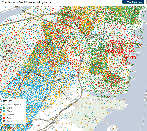 First impressions, according to the map: 1. There are almost no white people in Bergen/Lafayette. 2. Asians completely control Newport. (They are also the most geographically spread race across all of Jersey City.) 3. Hoboken is whiter than Rebecca Black.
Posted on: 2011/3/24 19:17
|
|||
|
||||